Mountain Biking at El Corte de Madera (aka Skeggs)
Overview | Rides | Logistics | Resources | Trail Conditions
El Corte de Madera (ECdM for short), located off of Skyline Blvd (Hwy 35) on the Peninsula of SF Bay Area between Hwy 84 and Hwy 92, is one of the preserves managed by Midpeninsula Regional Open Space District (MROSD) (more on this later). It is widely known within the mountain biking community as Skeggs Point, or Skeggs for short. The preserve is known for its dense trail system composed of both singletracks and fire roads under tall redwood trees, which makes it a great riding destination during the dry and warm seasons. Because most people park along Skyline Blvd to access the trails, many rides here are referred to by some as “credit card runs” because they typically start with a joyful descent and the rider has to pay for it later grinding the long climb back up. It sounds terrible, but you know it can’t be that bad when many mountain bikers call Skeggs their favorite place in the Bay Area to ride.
Overview | Rides | Logistics | Resources | Trail Conditions
These are a few rides I have put together stats and route descriptions for. Please click on the link in the table or scroll down for details. There, you can also submit your own ratings on each ride, which are reflected in this table within a few minutes.
- Ride 1: An 11 Mile Ride (incl. Blue Blossom, Crossover, Crosscut, Manzanita, and Resolution)
Stats and GPS: The same GPS track is available on MTBGuru, Garmin Connect, Plus3Network, and Strava.
Distance (mi) 11.5
Elevation Range (ft) 1421 – 2380
Total Ascent (ft) 2293
Route Directions: Skeggs Point Parking going north » enter CM01 » Paved road (up) » L: Sierra Morena Trail (down-ish) (pass CM02 and CM03 on the left) » exit CM04 » R: Skyline Blvd » R: Bear Gulch Road (up then down) » R: enter CM05 (easy to miss) » S: Spring Board Trail (down) » R: Blue Blossom Trail (easy to miss) (down and rolling) » S: Spring Board Trail (down and then up) » L: Spring Board Trail (flat/up) » R: Gordon Mill Trail (up) » L: Crossover Trail (up) » L: Crosscut Trail (flatish) » R: Timberview Trail (up) » L: Manzanita Trail (up-ish) » L: Fir Trail (down) » R: Resolution Trail (down) » R: El Corte de Madera Creek Trail (rolling, down, and then up) » L: short dirt road » exit CM01 » Skeggs Point Parking
The Scoop: This ride is recommended on Passion Trail Bikes website. It covers a few very popular trails. Skills to handle rocky climbs and descents are nice to have in order to avoid long stretches of hike-a-bike on Manzanita and Resolution. The distinct rock garden climb (after a dip) on Manzanita (Edit: no more as that section has been graded) and the Resolution Root are two challenging spots that some people like to stop at and even make a few attempts on. Other than those two trails, the rest of the ride is generally smooth.
Ratings:
- Ride 2. A 12 Mile Ride (incl. Manzanita, Crossover, Crosscut, lower Steam Donkey, Giant Salamander, North Leaf, and Resolution)
Stats and GPS: The same GPS track is available on MTBGuru, Garmin Connect, Plus3Network, and Strava.
Distance (mi) 12.3
Elevation Range (ft) 1316 – 2383
Total Ascent (ft) 2552
Route Directions: Skeggs Point Parking going north » enter CM01 » Paved road (up) » S: Fir Trail (down) » L and S: Manzanita Trail (down-ish) » R: Timberview Trail (down) » L: Crosscut Trail (easy to miss) (flat) » R: Crossover Trail (down) » S: Gordon Mill Trail (up) » R: (lower) Steam Donkey Trail (fast down) » R: Spring Board Trail (flat/up) » R: Gordon Mill Trail (up) » L: Crossover Trail (up) » L: Crosscut Trail (flatish) » L: Timberview Trail (down) » R: Giant Salamander Trail (rolling) » L: Methuselah Trail (down to creekcrossing and then up) » R: North Leaf (rolling) » R: Resolution Trail (up) » L: Fir Trail (up) » L: Tafoni Trail (rolling) » S: short dirt road » exit CM01 » Skeggs Point Parking
The Scoop: I came up with this ride to complement the previous one. There is very little overlap and repetition between these two rides. Each at 11-12 miles long, they can be easily combined into a bigger ride with the opportunity of replenishing at the car in between the two loops. This ride itself, just like the previous one, also covers many popular trails. On this ride, you get to enjoy Manzanita in its general downhill direction through a few rocky sections, but one rock garden after the distinct dip (to the the opposite side the rock garden you climbed in the previous ride) will force many riders off their bikes (for a very short section though). The ride then takes you down the lower section of Steam Donkey, which is a very fast descent. There are a few tricky step ups on North Leaf that require attention, but most are very do-able with one spot being more challenging than others. Resolution Trail will test your skills ascending rocky surface, but it is at least not loose. The rest of the ride will most likely see you flying (<15mph) down the smooth singletracks such as Giant Salamander, Methuselah, etc. Enjoy!
- Ride 3. A 20 Mile Descender’s Delight
Stats and GPS: The same GPS track is available on MTBGuru, Garmin Connect, and Strava.
Distance (mi) 22.3
Elevation Range (ft) 1413 – 2405
Total Ascent (ft) 4340
Route Directions: Skeggs Point Parking going north » enter CM01 » Paved road (up) » L: Sierra Morena Trail (down-ish) (pass CM02 and CM03 on the left) » exit CM04 » R: Skyline Blvd » R: Bear Gulch Road (up then down) » R: enter CM05 (easy to miss) » S: Spring Board Trail (down) » R: Blue Blossom Trail (easy to miss) (down and rolling) » S: Spring Board Trail (down and then up) » L: Spring Board Trail (flat/up) [optional loop: » R: Gordon Mill Trail (up) » R: (lower) Steam Donkey Trail (fast down) » R: Spring Board Trail (flat/up) /end optional loop] » R: Gordon Mill Trail (up) » L: Crossover Trail (up) » R: Crosscut Trail (flat) » S: Timberview Trail (up) » L: Methuselah Trail (up) » L: Manzanita Trail (down) » L: Timberview Trail (down) » R: Crosscut Trail (flat) » S/L: Timberview Trail (down) » R: Giant Salamander Trail (down and rolling) » R: Methuselah Trail (up) » L: Manzanita Trail (up) » L: Fir Trail (down) » R: Resolution Trail (down) [optional loop: » L: El Corte de Madera Creek Trail (down and up) » S: North Leaf Trail (down and rolling) » S/R: South Leaf new connector (really easy to miss this one even though there is a sign at the split because South Leaf is covered under leaves and Methuselah on the left looks much more traveled) » R: unmarked trail (right at the open area with a sign pointing to the rest of (more technical) South Leaf) » R: Star Hill Rd » R: trail towards CM07 (turn off before a house with a horse carral) » enter CM07 » L: El Corte de Madera Creek Trail (down, rolling, and then up) /end optional loop] » S: El Corte de Madera Creek Trail (down, rolling, and then up) » L: short dirt road » exit CM01 » Skeggs Point Parking
The Scoop: The route was basically an idea from MrCrash on MTBR with very minor modification (I added a little detour on Crosscut after Manzanita). I remember I laughed when I first saw his route — it had to have taken some brain power to come up with this route that does almost all the popular trails in the “right” direction. Then one day I went out and did it; I had a lot of fun and came up with the idea of calling it the Descender’s Delight because all the climbing was relaxing and all the downhill was simply joyful. As you can see in the track, the little loops (e.g. down Steam Donkey and down North Leaf & South Leaf New Connector) can be opted out if a shorter ride is more desirable. A word of caution: I got this feedback from my husband — most pure downhillers may not call this a descender’s delight. Why? Even though none of the climbs are technical, they seem long (compared to the all too fast descents) and there are a few steep sections on Timberview, Methuselah and ECdM trails, so the climbs may not seem so relaxing to everyone. Hmmm… I guess this is Skeggs, not North Star — climbing is mandatory.
P.S. if you would like to extend a route of this nature, please check out the Skeggs Lite ride below.
Ratings:
- Ride 4. Counter-Clockwise Perimeter Ride at Skeggs
Stats and GPS: The same GPS track is available on MTBGuru, Garmin Connect, Plus3Network, and Strava.
Distance (mi) 14.9
Elevation Range (ft) 841 – 2388
Total Ascent (ft) 3080
Route Directions: Skeggs Point Parking going north » enter CM01 » Dirt Road up then down » R: El Corte de Madera Creek Trail (down, rolling, and then up) » S: North Leaf Trail (down and rolling) » S/R: South Leaf new connector (really easy to miss this one even though there is a sign at the split because South Leaf is covered under leaves and Methuselah on the left looks much more traveled) » S: South Leaf Trail (technical, rolling) » S: Virginia Mill Trail (down) » R: Lawrence Creek Trail (down, then uuuuuup for a long time) » L/S: Blue Blossom Trail (entrance easy to miss) (down and rolling) » S: Spring Board Trail (down and then up) » L: Spring Board Trail (flat/up) » R: Gordon Mill Trail (up all the way) » L: Sierra Morena (at CM03, rolling then up after CM02) » R: Fir Trail » exit CM01 » Skeggs Point Parking
The Scoop: The earlier rides mainly explore the upper part of Skeggs. The far side has South Leaf Trail (most technical trail in the preserve), Virginia Mill Trail, and Lawrence Creek Trail. Since those trails contours the South perimeter, I had a GPS track shape in mind that would contours all the way around. This ride does it in the CCW direction. The climb on Lawrence Creek Trail was long at around 2.6 miles and is steep at spots. You do get rewarded by Blue Blossom after that climb, but if you want to call it a day at the end of that climb, you can easily escape to the road by taking Spring Board Trail to the right to exit either CM06 or CM05 and take Bear Gulch Road to Skyline (left) back to the car.
- Ride 5. Clockwise Perimeter Ride at Skeggs
eis
Stats and GPS: The same GPS track is available on MTBGuru, Garmin Connect, Plus3Network, and Strava.
Distance (mi) 15.5
Elevation Range (ft) 794 – 2352
Total Ascent (ft) 3640
Route Directions: Skeggs Point Parking going north » enter CM01 » Paved road (up) » L: Sierra Morena Trail (down-ish) (pass CM02 and CM03 on the left) » exit CM04 » R: Skyline Blvd » R: enter first un-numbered gate (where the yellow road sign is) » Upper Steam Donkey (down with some steep climbs) » S/L: Lower Steam Donkey (fast down) » S/L: Spring Board Trail (down and up) » L: Spring Board Trail (up, up and then down) (yield right twice) » L/S: Lawrence Crk Trail (down) » S/L: Virginia Mill Trail (down then up) » R: South Leaf (technical rolling) » S: South Leaf (new connector) (very fun rolling) » S: Methuselah Trail » S/R: North Leaf (rolling) » L: El Corte de Madera Creek Trail (down, rolling, and then up) » S: El Corte de Madera Creek Trail (down, rolling, and then up) » L: short dirt road » exit CM01 » Skeggs Point Parking
The Scoop: Because there is a CCW perimeter ride, there must be a CW perimeter ride. It’s just that simple. This ride features a descent of the entire Steam Donkey Trail. Because the upper section involves a couple of very steep short pictches that many descenders will not call delightful, it is not included in the Descender’s Delight ride. After descending Steam Donkey and climbing Spring Board Trail, the rider is faced with an option between continuing the climb on Spring Board Trail (featured in this track) and climbing Blue Blossom. I’ve done both and enjoyed both. One word of caution, Blue Blossom Trail is popular among riders coming down the other direction. If you have done the CCW perimeter ride and cursed the long climb on Lawrence Creek Trail, this is the time for your revenge — it is a long descent. The climb on Virginia Mill is not as bad. South Leaf will for sure be a challenge to most riders. North Leaf is less so, but there are a few tricky step ups that require attention. There are at least three options to end the ride: 1) Resolution to Tafoni Trail; 2) ECdM Creek Trail all the way, or 3) ECdM to Tafoni and again left on Tafoni. Option 2 is featured in this track just to make it a true perimeter ride.
Ratings:
- Ride 6. All of Skeggs, aka Skeggs Everything — every single inch of the trails
Stats and GPS: If you cannot download the track from above Strava activity, please leave me a comment below to get in touch and I can email the .gpx to you.
Distance (mi) ~43 miles
Elevation Range (ft) 781 – 2405
Total Ascent (ft) ~11k
Route Directions: There is a 1-mile long turn by turn directions that goes with a custom made map by Biking Brazilian on MTBR. Both the map (.jpg) and the directions (.pdf) are available in this post of his. If you don’t have MTBR account to access the attachment, you can get them here: Map and Directions. Note: Actually, new trails have been added in Skeggs since the original proposal was concinved, and I have changed up the sequence quite a bit after having ridden the ride five times. The YouTube shows the final most optimized (IMHO) version, but I guess you’ll have to know Skeggs fairly well to follow it. Or contact me and I’ll email you the track. P.S. Ken Goodson has contributed his cue sheet used on his Sept 2016 ride that started and ended at CM00, the official Skeggs Parking. Access the cue sheet and track at this link.Â
The Scoop: This route literally covers every single inch of the legal dirt trails at Skeggs. Because of that, there are some double backs on a few (not too many) trails, but most trails are covered not only one way, but also in the preferred direction. Overall, this is a extremely well thought out route. For ~42 miles and near 10K’ climbing, it is not to be taken lightly. Because there are so many entrances/exits in the preserve, bailout options are abundant. But if you do bail out or even skip some out and backs (including those short ones just to touch the gate), the ride can no long be called All of Skeggs, can it? My advice — go all out! If you do decide to do it, here are a few tips: You can read my ride report, which has some tips on what have helped me navigate effectively on this seemingly confusing route. Biking Brazilian’s suggestion of stashing at Point OO is pretty good. In hindsight, I think another stash at one of the gates on Skyline (CM01-CM04) would be nice too. Having done this route multiple times, I found that what worked well for me was to have one stash in the car that’s parked at CM08 and one at CM06 (after climbing Spring Board). You exit OO point to get back to the car after about 16 miles and then re-enter at OO point to continue the ride. You get to refuel every third of the ride. Another modification I made was I did the out and back on Spring Board after coming down Blue Blossom (before exiting CM06) instead of waiting to do it until after Steam Donkey. I wanted to get most of the climbing done as early as possible. It worked very well for me. P.S. For anyone who would like to do this ride, but does not feel sure or is not very familiar with the terrain, I strongly recommend doing the 1st half of this ride (see my Strave Ride link. We ended the ride by turning left after the Virginia Mill descent and finished off with Timberview – Giant Salamander – Methuselah. If climbing Timberview (between Gordon Mill and Giant Salamander) the second time upsets you, trust me, the long climb on Lawrence Creek and steep Spring Board climb on the later part of the Everything ride will feel much harder.
- Ride 6.1. All of Skeggs training ride — Half of Skeggs
Stats and GPS: The same GPS track is available on Garmin Connect.
Distance (mi) 22.5
Total Ascent (ft) 6182
The scoop: I took the hubby on this ride to show him the gist of All of Skeggs ride without the need for a full day. Afterwards, I liked this ride enough to recommend it, esp. to anyone who wants to train for the AoS ride. By putting you on a couple of the tougher climbs at Skeggs (e.g. Lower Fir and Timberview before Giant Salamander), it will help set the expectation for AofS, and the need for some out and backs will help establish the discipline that’s required to officially claim the completion of All of Skeggs ride.
Route Beta: I’m typing this up fast for an Internet friend. Please excuse the brevity.
- What do you need: The map as well as the PDF attachment from this MTBR post.
- Directions: Follow the route sheet (again, the PDF) all the way to point VV. After that, instead of turning back to point WW as on the AoS ride, you follow MM->Y->U->R->T and call it a day; hence, Half of Skeggs Ride.
- More Beta: 1) Stash at point OO as instructed. It might not be easy to find when you drive down the road, so it’s good to find it on this ride. 2) Stash your pack at the bottom of Lower Fir because you’ll come right back down it. 3) You can bail almost at any point on this ride, and it’s a fairly easy bail. But ask yourself, how bad do you want to do the AoS ride? 4) Check out my navigation tips in this post.
I don’t have time to form the rating gauges for this ride yet. But if you end up doing this one, please come back and put in a comment on how you like it. It by itself is a great ride full of challenges and its completion deserves many kudos.
- Ride 7. A fun moderately technical and non-physical short 10-mile loop
Stats and GPS: The same GPS track is available on MTBGuru, Garmin Connect and Strava.
Distance (mi) 9.6 (or ~10)
Elevation Range (ft) 1430 – 2602
Total Ascent (ft) 1986
Route Directions: Enter CM02 » turn right and up » Sierra Morena (up) » S: Fir Trail (down) » L and S: Manzanita Trail (down-ish) » L: Timberview Trail (down) » R: Crosscut Trail (flat) » S: Timberview (down) » R: Giant Salamander Trail (rolling) » L: Methuselah Trail (down to creekcrossing and then up) » R: North Leaf (rolling) » R: Resolution Trail (up) » L: Fir Trail (up) » L: Tafoni Trail (rolling) » S: short dirt road » R: short paved road » S: Fir Trail (flat) » L: Sierra Morena (down) » Exit CM02
The Scoop: This is one of my two favorite short loops at Skeggs now (the other one is listed as Ride 8). I call it non-physical because this loop does not include any very steep climb and the climb out from the bottom (i.e. the creek crossing on Methuselah) is broken up into a few ups and downs. However, there are a few moderately technical spots where riding over without dabbing — we call cleaning the spot — should justifiably earn you some kudos, for example, the rocky climb on Manzanita, the creek crossing, a few step ups on North Leaf, the root drop on Resolution, etc. To this day, Erik has cleaned all but the one rooty step-up on North Leaf, which he was very close at getting. One Strava segment on this ride that we pay attention to is Bottom of Methuselah to Top of Resolution.
P.S. It’s been a while and I forgot about Ride #2. After re-reading this page, I realize that the Ride 7 is very similar to Ride 2 except that it eliminates the extra loop to go down Lower Steam Donkey. A result is the elimination of the fairly long climb on a wide fireroad (to Lower Steam Donkey). You make a choice.
P.P.S. BTW, the reverse loop is equally fun. The GPS track is available on Strava and Garmin Connect.
Ratings:
- Ride 8. A non-technical but a little physical short 10-mile loop
Stats and GPS: The same GPS track is available on MTBGuru, Garmin Connect and Strava.
Distance (mi) 9.8
Elevation Range (ft) 1347 – 2382
Total Ascent (ft) 2350
Route Directions: Enter CM02 » L: Sierra Morena Trail (down-ish) (pass CM02 and CM03 on the left) » exit CM04 » R: Skyline Blvd » R: enter first un-numbered gate (where the yellow road sign is) » Upper Steam Donkey (down with some steep climbs) » S/L: Lower Steam Donkey (fast down) » S/L: Spring Board Trail (down and up) » L: Spring Board Trail (up, up and then down) (yield right twice) » R: Blue Blossom Trail (easy to miss) (down and rolling) » S: Spring Board Trail (down and then up) » L: Spring Board Trail (flat/up) » R: Gordon Mill Trail (up) » L: Crossover Trail (up) » R: Crosscut Trail (flatish) » L: Timberview Trail (up) » S-R: Manzanita Trail (up-ish) » L: Fir Trail (down) » R: Sierra Morena Trail (down) » L: Exit CM02
The Scoop: This loops is not technical, but there are a few very steep short climbs on Upper Steam Donkey and on Spring Board that may see many riders push their bikes. Otherwise, the downhill on Steam Donkey and Blue Blossom is a thrill. One Strava segment on this ride that we pay attention to is Whole SteamDonkey to top of Springboard. Considering that Steam Donkey is pretty much a one way trail (by common sense not by “law”), this segment is a test to over all descending and ascending skills.
- Ride 9.1. Locoyokel’s Skeggs Lite
Stats and GPS: The same GPS track is available on MTBGuru, Garmin Connect and Strava.
Distance (mi) 27.0
Total Ascent (ft) 6735
Route Directions (from Locoyokel): I hit the lap button everytime I reached the intersection of Manzanita and Methuselah, which I marked as a bail point in the above map.
– Lap 1 (10.51mi): Skeggs Pt – steep paved road to Fir for short bit – left on Sierra Morena all the way to CM04 – Skyline Road to Bear Gulch Road – Spring Board trail for short bit – left on connector to Lawrence Creek – right on Lawrence Creek for short bit – right on Blue Blossom – left down Spring Board – right up Gordon Mill to first right – lower Steam Donkey – up Gordon Mill to first left – Crossover – left on Crosscut – left down Timberview – right on Giant Salamander – right up Methuselah
– Lap 2 (2.42mi): right on Manzanita – left on Timberview – left on Methuselah –
– Lap 3 (9.01mi): right on connector to Fir – left on Fir – angled right to lower Tafoni (as opposed to sharp right to upper/traversing Tafoni) – left on El Corte de Madera trail all the way past Resolution and up past the creek – left on North Leaf – left on Methuselah for short section – right on easy-to-miss South Leaf – South Leaf all the way to Virginia Mill (passing two small connector trails on right) – right on Virginia Mill for short section to road – right on Star Hill Road to CM08 – down Methuselah trail to creek and all the way up the big hill
– Lap 4 (3.79mi): left on connector to Fir – left on Fir – right on Resolution – right on El Corte de Madera trail all the way back to Skeggs Point.
The scoop: I could also call this the Descender’s Delight on Steroid. It’s a lot of fun. Climbing is mandatory, but almost all is on fireroad. You can bail so many times at some many places. The only really technical section is on South Leaf between the first exit and the second exit. If you don’t feel like dealing with it, take the easy escape at the first exit, which has clear signage. Here is locoyokel’s beta: “For those of us who just can’t hack the whole thing (or who can’t manage to get a whole day off), I just did a “Everything lite” or “Everything Singletrack” yesterday, hitting nearly every singletrack segment in Skeggs in the “preferred” direction – 28 miles, maybe 5-6K? Not going too fast, with a heavy bike, and including all stops, it took 5 hours. I started/finished at CM03 but I will describe it as if you started at Skeggs Point. This is a pretty fun route that misses only upper Steam Donkey (which you could add easily) and a few tiny tidbits of singletrack – probably gets 95% of singletrack in Skeggs, nearly all in the “right” direction. Some time-saving measures (like riding back Star Hill instead of reversing the Leaf trails) could easily be switched for even more singletrack mile.”
- Ride 9.2.Skeggs Lite 2.0
(I made the map for you my dear reader. I conceived the ride in my mind while riding.)
Stats and GPS: The same GPS track is available on Garmin Connect and Strava.
Distance (mi) 26.0
Total Ascent (ft) 6085
Route Directions: Just like above ride, I’m breaking this ride up into laps for easy customization.
– Lap 1 (4.5mi): CM02 Enter gate – left on Sierra Morena to CM03 – Skyline Road to Bear Gulch Road – Spring Board trail for short bit – left on connector to Lawrence Creek – right on Lawrence Creek for short bit – right on Blue Blossom – left down Spring Board – right up Gordon Mill to first right to base of Crossover
– Lap 2 (optional) (1.4mi): continue up Gordon Mill – right down lower Steam Donkey – up Gordon Mill to base of Cross over again
– Lap 3 (3.9mi): left up Crossover – left on Crosscut – left down Timberview – right on Giant Salamander – right up Methuselah to top of Manzanita (but don’t go down it)
– Lap 4 (3.2mi): left on connector to Fir – left on Fir – right down Resolution – left down ECdM – left down North Leaf – left on Methuselah for short section
– Lap 5 (3.1mi): right on easy-to-miss South Leaf – South Leaf all the way to Virginia Mill (passing two small connector trails on right) – right on Virginia Mill for short section to road – right on Star Hill Road to CM08 and enter
– Lap 6 (2.7mi): right down Methuselah – all the way down to creek – continue all the way up to the top of Manzanita
– Lap 7 (optional) (2.4mi): right down Manzanita – left down and then up Timberview – left up Methuselah back to the top of Manzanita
– Lap 8 (2.7mi): straight up connector to Fir – left on Fir – right down the left branch of Tafoni – right down and roll and then up ECdM . (At the end you can ride up to Skeggs Point or straight over to Sierra Morena back to CM02.)
– Lap 9 (optional) (2.0mi): right down and roll Tafoni – left on Fir – right down Sierra Morena back to CM02. You are done!
The scoop: This ride covers most trails on the above Skeggs Lite ride, but I reordered the trails so I can go down Resolution and South Leaf not too late into the ride. These two trails require more focus if you aim to clean (without dabbing or pushing) as much as you can. I do like this version better in the end. By the stats, it appears just a tad easier than the original Skeggs Lite ride.
Overview | Rides | Logistics | Resources | Trail Conditions
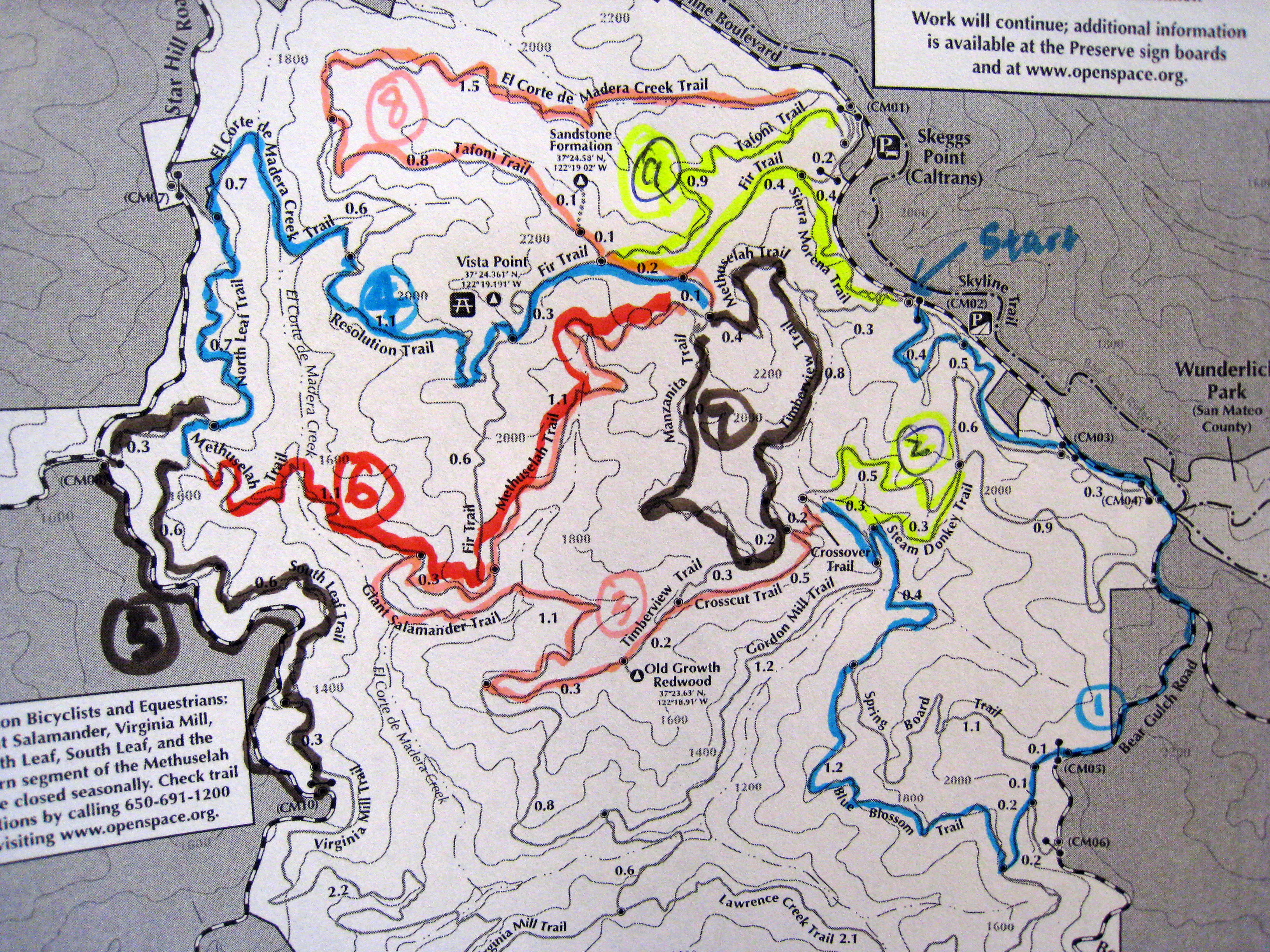
Please click on this Google Maps link for directions to the main Skeggs Point parking lot. Parking is free. But when you look at the map (see Resources below), there are a few other entrances to the openspace where people park and start their rides at such as CM02 (between Skeggs Point Parking lot and SR 84, aka La Honda Rd, intersection). And if you want to start your ride from Star Hill Rd, I suggest park at CM08 instead of CM07 because there is almost no parking unless you park in front the only house there.
There is no drinking water at the preserve, but I’m happy to report that from 2014 on, the parking lot newly installed at CM00 now has outhouses for pre-ride/post-ride relief. If you come up Hwy 84, there are restrooms and outhouses at the intersection of Hwy 84 & Hwy 35. There is a general store there as well if you need to purchase water or Gatorade. If you come down Hwy 35 from Hwy 92, there is an outhouse at the most prominent parking area for Purisima Creek OSP on your right.
Alice’s Restaurant at Hwy 84 & Hwy 35 has been a popular post-ride re-fuel station among mountain bikers. From what I heard, they serve good beers including those from the local Devil’s Canyon Brewery.
Should you visit with members in the family who do not hike or ride, Half Moon Bay is less than half an hour away via Hwy 92. And the San Gregorio State Beach at the end of Hwy 84 is a popular ocean beach for relaxing and picnicking.
Like other preserves under the management MROSD that actually allow mountain biking, there is 15 mph speed limit on the trails. The speed limit is often enforced by rangers equipped with radar guns. The fine for violation is usually a hefty sum.
Breakins have been reported at various locations (CM02, CM01 the Point, CM08, etc) around Skeggs. Try to secure your valuables by either taking them with you or stashing them out of sight.
Overview | Rides | Logistics | Resources | Trail Conditions
Usually, there are free maps provided by MROSD at the CM01, CM02, and CM03 entrances unless they have run out on a busy day. However, the favorite map I carry on my rides is the one I printed on regular paper from the online PDF file of the very same map. I strongly recommend having a map with you even if you have the GPS course or know the route you are doing. This is just in case someone on the trail encounters some serious mechanical or physical problems that require fast bailing to a paved road, you can find many outlets around the park that provide access to roads. They are not all marked or numbered.
Bike shops nearby include Passion Trail Bikes in Belmont and the Bike Works in Half Moon Bay. PTB also has a web page on ECdM that includes a map with difficulty ratings of the trails, which can come handy if you want to compose a ride with trails you’ve never been on.
For more GPS tracks, I recommend mtbguru.com. You type “Skeggs” in the search box and many tracks/courses can be found there.
Overview | Rides | Logistics | Resources | Trail Conditions
Please refer to the MROSD official ECdM page for the latest Trail Conditions (box on the right). This is especially important during the wet season because some trails may be closed and reopened depending on the precipitation.
Here are a few widgets and links that may help plan your trip.
|
CURRENT SUN
Time:
Rise:
Set:
|
CURRENT MOON
|
Cloud coverage over lay (from Naval Research Laboratory)
Web cam from Lick Observatory
Following are trail conditions submitted by trail users.
If you’ve just ridden in the area recently, we appreciate your updates on the trail conditions. Please submit the updates using this form below. (For general comments, please use the comment form at the bottom because it offers a subscription and a notification mechanism.)
- Comments(12)
Thanks for the Ecdm routes. I essentially did route 4 but my computer said 800 feet of climbing. Then I looked at the topos and your site and confirmed 2500-3000.
Thanks for confirming I’m not crazy.
Sm
Hi, thanks for the kind comments. Sounded like you got a very modest computer. Some people I know are into going into rides for the footage (e.g. 10K ride at Henry Coe), and your computer would put you in great disadvantage there. Haha! I’m sorry that I haven’t been keeping up with the route collections. I’m having way too much fun researching into our house remodeling these days.
[…] you are wondering what trails to ride, this site has some great […]
Hi Mudworm,
very impressive and useful blog!
Could you send me a .gxp file with the latest Skeggs everything route. I would like to try it this fall.
Thank you,
Dmitry
Hi Dmitry, thank you for dropping the kind encouragement. I’ve sent you the .gpx file via email. Please let me know of your thoughts after the ride. Enjoy!!!
[…] Skeggs Mountain Biker’s resource: … awesome assembly of tracks information and conditions… […]
Hi. On 1/1/15 I rode starting from the new parking lot (the one with the restrooms) then onto skyline down to bear gulch road and into a tiny segment of Laurence creek trail to blue blossom trail. After that, I rode onto a 0.4 mile segment of spring board trail then onto gordon mill trail to connect with sierra morena trail to the new parking lot. In early December, I rode a part of steam donkey trail and it was SO wet! P.S.: how mach difficultly do you think is blue blossom trail?
Hi kc, I only saw the comment today. To answer your question, Blue Blossom is usually not considered technical, esp. going from S to N. Hope you enjoyed it and want to come back to Skeggs for more. Wonder if you did your December ride after the big rain storm, but there is almost always some running water on Upper Steam Donkey, part of which I believe you rode.
I see lots of people riding HT at Skeggs, they also ride down Manzanita (rock garden) with ease, I don’t know how they do it… maybe it’s just me.. getting too old.
I’ve seen people ride cross bikes at Skeggs. I suppose you pick your weapon for the type of fun you aspire to. Each to their own. 😉
hello,
my friend and i have been contemplating “all of skeggs” for some time but have been struggling on how best to settle on an optimal route…just now I found your sites! great work!
I was able to download your 2013 gox route from garmin, but unable to download the improved and updated version from 2014 on strava, for some reason. wondering if you mght share your latest gpx including the new trails, or simply share how it differs from the 2013 version.
thanks!
You got it! The GPX is in the email. Go get her done!